


Saint George Island is a 20 mile long, and less than 1 mile wide, wooded barrier island located 5 miles off the north Florida gulf coast. A cut made through the western end of the island in the 1950s makes the 8 mile long Little St. George Island (Cape St. George State Reserve) inaccessible by land. St. Vincent Island lies just to the west. The islands partly shelter Apalachicola Bay and St. George Sound. On the far eastern end of the island is the 9 mile long St. George Island State Park.
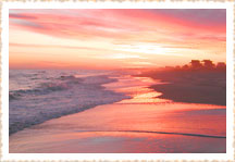
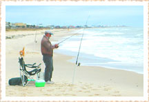
![]() The waters in the area are some of the most productive commercial and sport fisheries in Florida, with a thriving oyster industry at the mouth of the Apalachicola River. The beaches are among the best in the nation.
The waters in the area are some of the most productive commercial and sport fisheries in Florida, with a thriving oyster industry at the mouth of the Apalachicola River. The beaches are among the best in the nation.
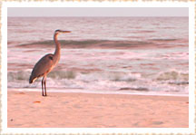
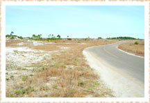
![]() The natural features of St. George are a combination of sandy coves, salt marshes, shady pines and oak forests. Wildlife abounds on the island. These include salt-marsh snakes and diamondback terrapin that reside in the marsh and bay waters. The island is also an important stop for migrating birds during the fall and spring. Birds such as the snowy plover, least tern, black skimmer, willet, and many other species of shorebirds, frequently nest along the island’s sandy shores and grass flats.
The natural features of St. George are a combination of sandy coves, salt marshes, shady pines and oak forests. Wildlife abounds on the island. These include salt-marsh snakes and diamondback terrapin that reside in the marsh and bay waters. The island is also an important stop for migrating birds during the fall and spring. Birds such as the snowy plover, least tern, black skimmer, willet, and many other species of shorebirds, frequently nest along the island’s sandy shores and grass flats.
Sea Turtle Nests
Be sure to read our page about the very important loggerhead sea turtle nesting season on St. George Island.
[ top of page ]
Estuary
The Apalachicola and St. George Island area is one of only 25 protected estuaries in the U.S.
![]() Are you wondering what an estuary is?
Are you wondering what an estuary is?
![]() When you mix the fresh water of a river with the salt water of the sea, something wonderful happens, as if by magic, a life-supporting habitat is created for thousands of species of fish, birds, and mammals.
When you mix the fresh water of a river with the salt water of the sea, something wonderful happens, as if by magic, a life-supporting habitat is created for thousands of species of fish, birds, and mammals.
![]() This protected body of water, often partially enclosed by reefs, barrier islands or fingers of land is distinct from all other places on earth. In fact, it is irreplaceable.
This protected body of water, often partially enclosed by reefs, barrier islands or fingers of land is distinct from all other places on earth. In fact, it is irreplaceable.
![]() Estuaries are the most productive ecosystems on earth, containing more life per square inch than the richest farmland or deepest forest.
Estuaries are the most productive ecosystems on earth, containing more life per square inch than the richest farmland or deepest forest.
[ top of page ]
St. George Island History
The history of St. George Island is a colorful one, including tales of pirates, Indians, hidden treasures and shipwrecks. The Creek indians around the tenth century AD first inhabited St. George.
![]() Several indian middens are located near the Apalachicola Bay side of the Island and tourists walking along the bay frequently find pottery fragments. Decorated pottery, arrowheads,tools and other artifacts are found during low tide along the bay shoreline. By law any artifacts found on St. George should be reported to the state’s Bureau of Archaeology Research. Antique bottles are also occasionally found along the bay shoreline, many island residents have large collections dating back to the mid-nineteenth century. (The state is looking for those residents!)
Several indian middens are located near the Apalachicola Bay side of the Island and tourists walking along the bay frequently find pottery fragments. Decorated pottery, arrowheads,tools and other artifacts are found during low tide along the bay shoreline. By law any artifacts found on St. George should be reported to the state’s Bureau of Archaeology Research. Antique bottles are also occasionally found along the bay shoreline, many island residents have large collections dating back to the mid-nineteenth century. (The state is looking for those residents!)
![]() The first Europeans to discover St. George Island may have been the 1528 expedition of Panfilo de Navarez that followed the Panhandle coastline. This trip was recorded by one of the survivors, Cabeza de Vaca. By the mid-seventeenth century, the Spanish occupied the Gulf area with a fort at St. Marks and the Franciscan friars had established missions throughout Florida.
The first Europeans to discover St. George Island may have been the 1528 expedition of Panfilo de Navarez that followed the Panhandle coastline. This trip was recorded by one of the survivors, Cabeza de Vaca. By the mid-seventeenth century, the Spanish occupied the Gulf area with a fort at St. Marks and the Franciscan friars had established missions throughout Florida.
![]() Pirates roamed the Gulf waters seeking gold that Spain regularly transported from the New World. During the eighteenth century, pirates reportedly buried treasure near a camp on St. Vincent Island. Several shipwrecks from the Spanish Grand Fleet are also reported in this area.
Pirates roamed the Gulf waters seeking gold that Spain regularly transported from the New World. During the eighteenth century, pirates reportedly buried treasure near a camp on St. Vincent Island. Several shipwrecks from the Spanish Grand Fleet are also reported in this area.
![]() William Augustus Bowles, a european ship captain, pirate, and adventurer figured prominently in Florida political affairs during the late 1700s. People believe that he buried treasure on the western end of St. George (now Little St. George Island) after deliberately beaching his ship to avoid capture by the spanish. Billy Bowlegs Rodgers, another pirate and onetime comrade of the notorious Jean Laffite, also raided the waters of the Gulf of Mexico in his ship the Mysterio, and reportedly buried treasure in the area in the early 1800s.
William Augustus Bowles, a european ship captain, pirate, and adventurer figured prominently in Florida political affairs during the late 1700s. People believe that he buried treasure on the western end of St. George (now Little St. George Island) after deliberately beaching his ship to avoid capture by the spanish. Billy Bowlegs Rodgers, another pirate and onetime comrade of the notorious Jean Laffite, also raided the waters of the Gulf of Mexico in his ship the Mysterio, and reportedly buried treasure in the area in the early 1800s.
![]() In 1803, the Creek and Seminole indians ceded almost 2 million acres of land to the John Forbes Company to settle unpaid debts to the many mercantile establishments of that company; St. George Island was a part of the Forbes Purchase.
In 1803, the Creek and Seminole indians ceded almost 2 million acres of land to the John Forbes Company to settle unpaid debts to the many mercantile establishments of that company; St. George Island was a part of the Forbes Purchase.
![]() John Lee Williams took refuge on St. George Island in 1823 when a storm interrupted his return to Pensacola after his historic rendezvous with Dr. John Simmons to choose the site for the Florida Territorial Capital (now the city of Tallahassee). The plentiful oysters and crabs of Apalachicola Bay lessened the hardships caused by a shortage of food.
John Lee Williams took refuge on St. George Island in 1823 when a storm interrupted his return to Pensacola after his historic rendezvous with Dr. John Simmons to choose the site for the Florida Territorial Capital (now the city of Tallahassee). The plentiful oysters and crabs of Apalachicola Bay lessened the hardships caused by a shortage of food.
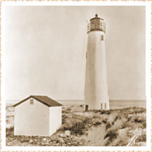
![]() A boom in commercial trading along the Apalachicola River led to the rapid growth of the port of Apalachicola and necessitated the construction of a lighthouse on St. George Island in 1833. Serving as a navigational aid for the increased boat traffic, it was moved to a more visible, westerly site in 1848, destroyed by a storm, rebuilt in 1852, rebricked in 1948, and still stands on Little St. George Island.
A boom in commercial trading along the Apalachicola River led to the rapid growth of the port of Apalachicola and necessitated the construction of a lighthouse on St. George Island in 1833. Serving as a navigational aid for the increased boat traffic, it was moved to a more visible, westerly site in 1848, destroyed by a storm, rebuilt in 1852, rebricked in 1948, and still stands on Little St. George Island.
![]() During the Civil War, the port of Apalachicola was strategically important to both sides. In 1862, Apalachicola came under the control of the Union blockade and was effectively neutralized.
During the Civil War, the port of Apalachicola was strategically important to both sides. In 1862, Apalachicola came under the control of the Union blockade and was effectively neutralized.
![]() After 1865, Apalachicola never regained its prewar importance as a cotton-shipping port; the completion of the railroads dealt a crushing blow to the economy. Nearby St. George Island had a complex succession of owners. The island’s pine forests were turpentined, cattle were grazed there, and a charming seaside hotel bloomed and faded during the early 1900s.
After 1865, Apalachicola never regained its prewar importance as a cotton-shipping port; the completion of the railroads dealt a crushing blow to the economy. Nearby St. George Island had a complex succession of owners. The island’s pine forests were turpentined, cattle were grazed there, and a charming seaside hotel bloomed and faded during the early 1900s.
![]() William Lee Popham, the famous Oyster King, was the first developer of St. George Island during the late 1910s and 1920s. Popham ran the hotel/restaurant, established a ferry to St. George and sold real estate as well as managing his oyster processing business. He built a boardwalk across the Island, from the Bay to Gulf, for prospective buyers.
William Lee Popham, the famous Oyster King, was the first developer of St. George Island during the late 1910s and 1920s. Popham ran the hotel/restaurant, established a ferry to St. George and sold real estate as well as managing his oyster processing business. He built a boardwalk across the Island, from the Bay to Gulf, for prospective buyers.
![]() The Army Corps of Engineers dredged the Bob Sikes Channel or The Cut, as it is commonly known, in the 1950s. Then a group from Tallahassee platted the St. George Island Gulf Beaches neighborhood and started selling lots. There are still houses in the middle of the island dating back to this period.
The Army Corps of Engineers dredged the Bob Sikes Channel or The Cut, as it is commonly known, in the 1950s. Then a group from Tallahassee platted the St. George Island Gulf Beaches neighborhood and started selling lots. There are still houses in the middle of the island dating back to this period.
![]() The entire island, less sales in the Gulf Beaches, was purchased in 1970 by John R. Stocks, a Tallahassee real estate developer originally from Huntsville, Alabama. Assisted by attorney Gene D. Brown, also from Tallahassee, Leisure Properties (their partnership) sold Little St. George island and the last nine miles on the East End to the State of Florida.
The entire island, less sales in the Gulf Beaches, was purchased in 1970 by John R. Stocks, a Tallahassee real estate developer originally from Huntsville, Alabama. Assisted by attorney Gene D. Brown, also from Tallahassee, Leisure Properties (their partnership) sold Little St. George island and the last nine miles on the East End to the State of Florida.
![]() Leisure Properties then sold five and eight acre tracts on the East End. St. George Plantation, opened in 1976, was Leisure Properties premier development. The Plantation featured an environmentally sensitive site plan with protective covenants to maintain the pristine qualities of the property.
Leisure Properties then sold five and eight acre tracts on the East End. St. George Plantation, opened in 1976, was Leisure Properties premier development. The Plantation featured an environmentally sensitive site plan with protective covenants to maintain the pristine qualities of the property.
![]() Since the completion of the original Bryant Patton Bridge in 1965, which connects St. George Island to the mainland, the island’s economy has depended on tourism and an active real estate market. The new St. George Island Bridge opened for traffic on Feb. 16, 2004, and is the third longest bridge in the state. The island currently boasts a permanent population of about 700 people.
Since the completion of the original Bryant Patton Bridge in 1965, which connects St. George Island to the mainland, the island’s economy has depended on tourism and an active real estate market. The new St. George Island Bridge opened for traffic on Feb. 16, 2004, and is the third longest bridge in the state. The island currently boasts a permanent population of about 700 people.
View a photo (Flash) tour of The Homes of St. George Island here.
[ top of page ]
Historical Marker
The following Florida Historical Society marker is located inside the St. George Island State Park.
William Augustus Bowles
During a storm in 1799, the schooner Fox ran aground off the eastern end of St. George Island. On board was William Augustus Bowles, a British citizen and self-styled leader of the Creek-Cherokee nation. Bowles was retuning to Florida having escaped after five years as a Spanish prisoner. Bringing gunpowder and bullets, he hoped to re-establish his prominence among the Creeks, drive the Spanish out of Florida, and create an independent Muskogee state under British protection.
![]() The Creeks were the most organized of the southern Indians and still controlled much of their territory. Because of Florida’s strategic location, the U.S., Spain, Britain, and France were all interested in Bowle’s actions. With supplies salvaged from the shipwreck, Bowles paddled up the Apalachicola River to reunite with his Creek family and begin rallying native support. The ship captain and crew camped on the island until rescuers returned them to Jamaica.
The Creeks were the most organized of the southern Indians and still controlled much of their territory. Because of Florida’s strategic location, the U.S., Spain, Britain, and France were all interested in Bowle’s actions. With supplies salvaged from the shipwreck, Bowles paddled up the Apalachicola River to reunite with his Creek family and begin rallying native support. The ship captain and crew camped on the island until rescuers returned them to Jamaica.
![]() Bowles and his Creek, Seminole, black, and white followers captured the Spanish fort at St. Marks in 1800 and held it for over a month. Losing control of its only fortification between St. Augustine and Pensacola was an embarrassment to Spain and a sign of its fragile hold on Florida. Britain’s peace with France and Spain through the Treaty of Amiens, 1802, removed any hope of British support for Bowles’ schemes. Bowles lived among the Creeks until his recapture in 1803, and died in a cuban prison. Although Bowle’s dreams were not realized, he plagued the Spanish for almost two decades, preventing them from maintaining complete military control of Florida.
Bowles and his Creek, Seminole, black, and white followers captured the Spanish fort at St. Marks in 1800 and held it for over a month. Losing control of its only fortification between St. Augustine and Pensacola was an embarrassment to Spain and a sign of its fragile hold on Florida. Britain’s peace with France and Spain through the Treaty of Amiens, 1802, removed any hope of British support for Bowles’ schemes. Bowles lived among the Creeks until his recapture in 1803, and died in a cuban prison. Although Bowle’s dreams were not realized, he plagued the Spanish for almost two decades, preventing them from maintaining complete military control of Florida.
Forgotten Coast
Florida’s Forgotten Coast is the most spectacular, and pristine, in the country. Its natural beauty has been preserved through a series of planned and unplanned events.
The Forgotten Coast takes in a stretch of coastline from St. Marks Wildlife Refuge east through Mexico Beach to the west. This stretch of coastline crosses four counties rich in history, Wakulla, Franklin, Gulf and Bay.
![]() The first inhabitants in the area were the Creek and Seminole indians. Often, people walking along the shorelines of canals, bays, and creeks still find Indian artifacts such as tools, arrowheads, and pottery fragments.
The first inhabitants in the area were the Creek and Seminole indians. Often, people walking along the shorelines of canals, bays, and creeks still find Indian artifacts such as tools, arrowheads, and pottery fragments.
![]() The first europeans to discover the forgotten coast were in the Panfilo de Narvarez expedition of 1528 that followed the Panhandle coastline.
The first europeans to discover the forgotten coast were in the Panfilo de Narvarez expedition of 1528 that followed the Panhandle coastline.
![]() By the mid-17th century, the Spanish occupied the Gulf coastal area with a fort at St. Marks in Wakulla County at the eastern end of the forgotten coast.
By the mid-17th century, the Spanish occupied the Gulf coastal area with a fort at St. Marks in Wakulla County at the eastern end of the forgotten coast.
![]() Crawfordville is the county seat of Wakulla County. The county has a Rails to Trails park stretching from just south of Tallahassee to St. Marks on the coast. This trail follows the bed of the historic St. Marks railroad. Many of this county’s woods were home to our native Americans providing abundant wildlife and many natural lakes for fishing. Much of these forests are apart of the Apalachicola National Forest.
Crawfordville is the county seat of Wakulla County. The county has a Rails to Trails park stretching from just south of Tallahassee to St. Marks on the coast. This trail follows the bed of the historic St. Marks railroad. Many of this county’s woods were home to our native Americans providing abundant wildlife and many natural lakes for fishing. Much of these forests are apart of the Apalachicola National Forest.
![]() The center of the forgotten coast is Franklin County, just west of Wakulla County. The county seat, Apalachicola, is at the mouth of the Apalachicola River and at the head of the Apalachicola Bay. The location alone led to a rapid commercial trading boom that resulted in the city becoming an important cotton shipping port in the 1800s, and the necessity for a lighthouse to be constructed on nearby St. George Island to serve as a navigational aid for the increased boat traffic. After 153 years, and several attempts to preserve the 74-foot-tall brick lighthouse, it was found toppled and collapsed on October 21st of 2005.
The center of the forgotten coast is Franklin County, just west of Wakulla County. The county seat, Apalachicola, is at the mouth of the Apalachicola River and at the head of the Apalachicola Bay. The location alone led to a rapid commercial trading boom that resulted in the city becoming an important cotton shipping port in the 1800s, and the necessity for a lighthouse to be constructed on nearby St. George Island to serve as a navigational aid for the increased boat traffic. After 153 years, and several attempts to preserve the 74-foot-tall brick lighthouse, it was found toppled and collapsed on October 21st of 2005.
![]() The shift in transportation methods in the mid-1800s from river shipping to trains focused regional and national attention away from the forgotten coast.
The shift in transportation methods in the mid-1800s from river shipping to trains focused regional and national attention away from the forgotten coast.
![]() As early as the 1910s, the harvesting of the Apalachicola Bay oysters became a mainstay industry for the area. The commercial shrimping, fishing, and oystering industry is still one of the most active in the state.
As early as the 1910s, the harvesting of the Apalachicola Bay oysters became a mainstay industry for the area. The commercial shrimping, fishing, and oystering industry is still one of the most active in the state.
![]() The next county west is Gulf county with Port St. Joe as its county seat. Port St. Joe was the site of the State’s first Constitutional Convention in 1838. The city has the State Constitution museum with exhibits relating to the drafting of the Constitution, as well as other major historical events of the city, i.e. the yellow fever epidemic and the devastating tidal wave around the turn of the century.
The next county west is Gulf county with Port St. Joe as its county seat. Port St. Joe was the site of the State’s first Constitutional Convention in 1838. The city has the State Constitution museum with exhibits relating to the drafting of the Constitution, as well as other major historical events of the city, i.e. the yellow fever epidemic and the devastating tidal wave around the turn of the century.
![]() In the late 1800s the St. Joe Paper Company purchased thousands of acres of land and planted pine trees to supply the paper company's need for pulp wood. Recycling of paper products and new technology for producing paper has diminished the demand for the growing and harvesting of the pine trees. St. Joe is now known as St. Joe Development Corporation and plans to refocus its activities. The pine forests, however, controlled the availability of land in the forgotten coast, and development occurred in other more accessible areas.
In the late 1800s the St. Joe Paper Company purchased thousands of acres of land and planted pine trees to supply the paper company's need for pulp wood. Recycling of paper products and new technology for producing paper has diminished the demand for the growing and harvesting of the pine trees. St. Joe is now known as St. Joe Development Corporation and plans to refocus its activities. The pine forests, however, controlled the availability of land in the forgotten coast, and development occurred in other more accessible areas.
![]() Environmental laws and policies played a key role in preserving the forgotten coast over the past 25 years. While other areas across Florida welcomed large-scale development, local policies here were designed to protect the seafood fisheries and industry.
Environmental laws and policies played a key role in preserving the forgotten coast over the past 25 years. While other areas across Florida welcomed large-scale development, local policies here were designed to protect the seafood fisheries and industry.
![]() The forgotten coast used federal, state, and local development restrictions to enhance the pristine qualities of the area. Florida’s forgotten coast offers a low-density, environmentally protected area that is unequaled in beauty.
The forgotten coast used federal, state, and local development restrictions to enhance the pristine qualities of the area. Florida’s forgotten coast offers a low-density, environmentally protected area that is unequaled in beauty.
[ top of page ]
[ who ] [ what ] [ where ]
all content ©2004-08 johnpaul /design